


Mankind is at greater risk from both natural hazards and many manmade hazards than at any other time in history.
Think about that statement for a moment. I know I do. This is why I try to write about what I am working on in my personal emergency preparedness and survival efforts, or to work on my preparedness related to topics, to kill two birds with one stone, so to speak.
One of my long-term projects is my own personal Modular Survival Kit which is one of the primary frameworks for my personal emergency preparedness efforts. From that framework hangs a smaller project which is called the Digital Survival Library and my personal digital map collection is part of that project.
I have been working on it and thought I’d document some bits and pieces to share with my friends who read Surviopedia. Make a list and check them one by one as you get them, you will later make good use of these survival resources!
12 Strategic Planning Maps Sources for Location Selection
I have listed some resources for the USA and a few for maps abroad, but if you live or own property outside the US, you may need to look up the equivalent entity in that country. I wouldn’t buy paper copies of the maps here unless they are in books since you only need them to plan.
1. USGS Natural Hazards Maps
This is probably most all-encompassing natural hazards map site I know of and includes tsunami, earthquake, geomagnetism, landslide, volcano, astrogeology, flood, drought and wildfire hazards. It even includes quite a bit of information for foreign nations.
2. FEMA Earthquake Hazard Maps
This one will show you how earthquake hazards vary across the United States.
3. FEMA Flood Map Service Center – gov
They can help you understand flood insurance rate maps.
4. National Geospatial Intelligence Maps
They are good for studying all kinds of things from nuclear power plants to polar ice and climate change.
5. US Nuclear Reactors, Nuclear Power Plants & Seismic Hazard
It wouldn’t take a tsunami to cause a severe nuclear accident in the US. Note where the nation’s 104 nuclear reactors are and note 10 & 50 mile zones around plant and take prevailing winds into consideration.
6. Nuclear Target Maps
You won’t find any current nuclear target maps on-line, as any current information is going to be secret compartmented. That said, there is plenty of outdated, declassified material available in on-line archives.
One of the greatest nuclear risks today is that a single nuclear weapon or small number of them will be detonated in major cities. New York and Washington DC are major targets as are many significant and/or populous cities, but it’s largely speculation so I won’t include nuclear target maps on this topic for planning purposes, but do observe likely fallout patterns from major cities.
7. Nukemap
In case you want to simulate weapons effects in nearby cities. Helpful for creating realistic training scenarios and choosing locations of fixed sites.
8. EarthExplorer
Think of it as the USGS version of Google Earth … only you can go back in time. Some of the first generation of US satellite imagery taken between 1960 & 1972 has been declassified, so it you want imagery of areas unlikely to change since then you have a free resource now.
9. Google Earth
As every criminal casing your home and retreat knows, Google has invested crazy resources to make Google Earth a fairly-up-to-date tool for ever-increasing swaths of the planet … especially most places most folks reading this live, own property or plan to hole up. If that’s not OK with you, get your place blacked out by telling them you run a child day care, but save some images before you do for your own use.
For survival use, I recommend the Offline Installer for Google Earth. Zoom in areas of interest and snap and print what you need, mark them with the scale, indicate magnetic declination, label and print them and you have useful maps.
10. Books
There are many fine books on the subject containing a number of maps and guidelines – Rawles on Retreats by JW Rawles and Strategic Relocation by Joel Skousen are a couple of good ones.
11. Threat-specific Online Searches
Search for hazard maps for threats you are concerned about, they will help you a lot.
12. Digital Survival Library
Use technology, but don’t become dependent on it. To this end, I curate a very useful collection of data that is my personal Digital Survival Library and as you probably guessed, it contains a ton of maps. I store it on pairs of volumes on ruggedized media.
The first volume is not encrypted and contains information necessary to treat me in an emergency and some selections from my library that I would like anyone who happens up on to have access to.
The other volume is encrypted and contains a vast library of books, maps, emergency communications plan, emergency plans, insurance information, medical records, photos, genealogy, music, scans of documents, software, driver and a backup of all my important data that I never want to be without. I scan and shred anything that can be, so it’s a lot of data.
It also includes all the software necessary to make any phone of computer I come across read every file type of maps and other files in the library, drivers to print, program amateur radios and everything else I could anticipate that a survivalist would need.
It is comforting to know that if my plane drops out of the sky and I find myself on some island in the Caribbean or in South America I have a map and access to my library … maybe I won’t have a map in the level of detail I would like, but chances are good that it would be useful.
13 Essential survival items are included inside this kit. Grab this offer now!
How to Make Your Own Digital Survival Library
If you make one for yourself, here are a few things to keep in mind.
Stash portions of your DSL on an encrypted server outside the US to make sure you can hop on line an access it from anywhere … as long as the internet is still up.
Cache copies in separate sites. Info caches can be very small so it’s no big deal to stash encrypted copies in places you could find yourself stranded.
It you have need, you can stash a copy on a rugged MicroSD card concealed in a hollowed-out coin, under a band-aid or any imaginable object of sufficient dimensions.
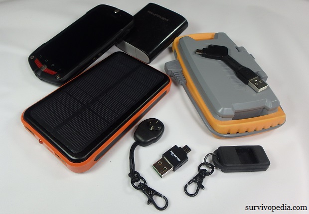
Carry a copy on your keychain in a flash drive or adapter that can connect to both cell phones and computers.
Be careful about usingcellphones. Most people carry a powerful computer in their pocket, but haven’t configured it for use as a standalone computer, they are very portable and common. Sufficiently small cell phones are likely to survive EMP as a standalone tool even though they contain a lot of vulnerable circuitry because they lack the conductor length to pick up sufficient charge from an incident of typical (50kVA/m) field strength at a distance.
Their small size and low cost make it a simple matter to shield them against more intense super-EMP field strengths and to cache backup phones in Faraday cages. Make sure your phones have the all the software and drivers to get the most of out of your phone in an emergency. If you root a phone and remove all the balloon-ware and tracking software cell providers pre-load phones with, even old phones are plenty powerful to be very useful.
As with all digital maps, GPS’s make it possible to carry more maps, greater detail and more current information as long as you are willing to shell out the dough. They are great tools. Use them, but don’t become dependent on GPS’s, cellphones, PLB’s or anything else that runs on batteries.
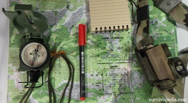
Get proficient in orienteering with map and compass first and then add GPS’s and a DSL on top of a strong foundation of map and compass land navigation. Every year, I read about hikers dying from injuries and/or exposure when gizmo’s fail, leaving them stranded.
SERE Maps
Keep copies of a couple small maps in your PSSRK (Pocket Survival and Self-recovery Kit) so you will always have a map on your person. Update them as you move around. Even if you know the area like the back of your hand, not everyone will and maps have a number of other uses besides finding your way.
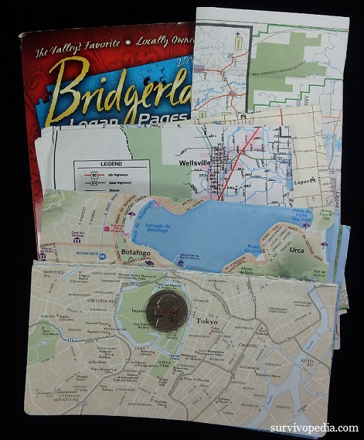
Phone Book Maps
If you find yourself without a map in a populated area, a decent map for Survival, Evasion, Resistance, Escape (aka SERE) purpose can be had for free from any phonebook. You can often find old phonebooks in or near dumpsters or at recycling centers.
Make sure you have the social engineering skills to get your hands on one from any business or residence without putting yourself at risk stealing. Hotels and churches often print small maps on fliers and the latter have aided in prison escapes.
Tyvek
Tyvek is a waterproof, tear-resistant ultralight material that can aid in the construction of a shelter in a pinch … great for SERE maps. The Federal Publications Inc website in Canada prints maps of Canada on Tyvek as do US companies that change so frequently I won’t waste your time with a link … or you can DIY.
Fabric
There is a storied history of blood chits and E&E maps silkscreened or traced onto fabric and sewn into the lining of jackets.
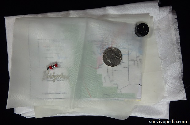
Silk is durable and fire resistant. Polyester taffeta burns thoroughly and quickly without producing hardly any smoke upon exposure to a lighter or other flame. Choose material based on need. Both fabrics pack great in pocket kits.
Light Source
Make sure you can read your maps in the dark. Less-overt colors of low brightness are more covert and preserve night vision, also tend to make ink of the same wavelength disappear, making them less-effective for use with maps that use those colors.
Because of this, I use the Petzl STRIX IR a lot which is a headlamp that can produce red, green, blue white or IR light of low intensity or more intense white light depending on the situation.
UV Light & Marker
A small UV LED can be used to read notes written with UV ink that are normally invisible to the naked eye. UV LEDs and pens can also useful for marking and signaling dead drops, for visual communications and the LEDs for finding biomatter, and scorpions.
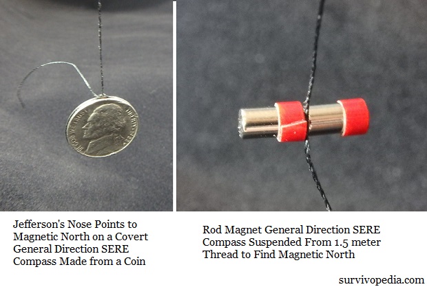
General Direction SERE Compass
If you do manage to survive with only the contents of your pockets in unfamiliar terrain, your map won’t be effective unless you orient it.
Maps for Travel, Recreation and Emergency Preparedness
You will want paper copies of these where possible. Digital copies can often be had for free, so get those either way. Store digital copies of your paper maps for use on your cell phones and computers. Scan maps that you only have on paper.
Neighborhood Maps for Emergency Response
I keep these in an emergency-response binder.
By collecting and updating maps, I have accurate maps showing every home and who lives in it, not only my neighborhood but also in surrounding neighborhoods. This information greatly simplifies the process of Block Captains and Co-Captains should keep maps of the neighborhood to mark off which homes need assistance in the event of a disaster incident.
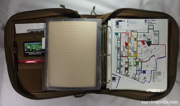
Each neighborhood gets checked off house by house in each block with blocks reporting to neighborhood EOC’s (Emergency Operations Centers) and Neighborhood EOC’s reporting to Area or Municipality EOC’s. You can find out more about how the program works from your local CERT Program. Find a CERT Program Near You
US Geological Survey
You can download all the maps you want for free or order printed maps at reasonable cost.
Another option with the USGS is that you can send them media and they will send you the maps you request or even a copy of the entire inventory, but you had better send a big drive since that would be several TB of data at this writing. That would take quite a while to download over most connections, so perhaps that’s why they provide the service.
- 1:24K Topo Maps – High level of detail when on foot.
- 1:100K Topo Maps – A little larger scale for traveling by vehicle.
USDA Forest Service Maps
They typically cost $12-$14 for printed copies.
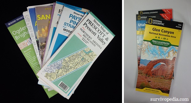
US National Park Maps
Download for free or buy paper copies for typically $9-$12ea. Set the page to the maximum number of products per page so you don’t have to scroll through as many pages.
National Geospatial-Intelligence Agency Map
Similar to EarthExplorer. Save digital copies and print paper ones.
Maps for Your Vehicle
City Maps
City maps are a must. I make it a point to pick them up wherever I travel, in advance when possible.
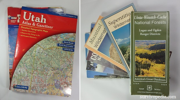
Topo Maps of the Entire State
These atlases and gazetteers by DeLorme and possibly competitive products are useful for traveling back roads and forest service roads by vehicle. This is important because you never know when an unforeseen emergency may force you to flee in an unplanned direction over back roads.
The scale isn’t large enough to be of much use on foot unless you have a lot of ground to cover, but pages or parts of pages could serve as E&E maps while traveling and is great for long drives. Invest in plastic covers and cases for these if you want them to last banging around in a vehicle.
Cost is about $15-$20 for most states and a little more for larger states or states with a lot of detail. I make sure I carry atlases for all of the states I am traveling and the adjacent states out West. Back in the Northeast where sizes of states are smaller I would make sure I had atlases for 2-4 states away from planned routes.
US Road Atlas
They are long distance backup to the above atlases.
Compact Phone Book
Maps and direction finding are more effective with a destination in mind. As soon as your cell tower, the grid or the internet go down, google and online maps will no longer work and you will find yourself reaching for something your probably don’t use much any more … a phone book … provided you are old enough to know what they are and how to use one, that is.
Custom Maps
Custom Maps Printed by University Libraries
Cheapest source of custom maps I have found. I had a university library print some color topographical maps on water-resistant paper in the same detail a the USGS topo maps. They are very large, about the size of 2 USGS topo maps high x 3 wide centered on areas of my choice.
They cost about $6 each which is an outstanding value! USGS topos would have cost me 6x as much, not come on water-resistant paper and aren’t centered where you like so you always seem to end up hiking through 2-4 maps per day, which means you have to line up the edges multiple maps.
DIY
Print maps at home. Depending on how many maps you print, what software you use and what you print them on, this can range from very inexpensive to expensive.
In addition to the USGS, there are several private websites which also offer free, printable maps online. I have printed some useful ones using Google Earth.
Custom Maps
mytopo and a few other companies have websites with easy to use interfaces that enable you to order custom maps of every sort imaginable. They have useful hunting products as they can display public vs private land, land owners and hunting areas. They are more expensive, but not ridiculously, so. Price varies by size and type.
Also check out their Backpacker Magazine Pro Maps if you are a backpacker.

This article has been written by Cache Valley Prepper for Survivopedia.


I get many of my Topographic maps from MyTopo.com. I usually order mine in either 1:25000 or 1:50000 scale with the military 1000 meter grid across the map. I get the table sized and in the standard size MyTopo prints. At the moment I have my current city and some areas around here. I also pick up the free state highway maps my state puts out.
I have both Alpine Maps and Offline Maps on my cellphone. Both access GPS WITHOUT needing cell towers or internet. Very accurate! I have portable solar panels that can recharge my phone as well as my GPS.