


Navigation today is all about using a GPS.
Need to go to a store? Grab your phone and put the GPS to work. Meeting someone for coffee? Grab the GPS again. The convenience of GPS has drastically changed people’s relation to the world around them, replacing a map and compass as the preferred means to find your way from here to there.
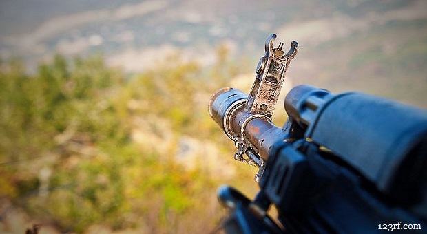
I still remember when GPS first came out. I was an artillery officer then and we were some of the first to make use of it. Rather than having a whole platoon of surveyors determining where we should set up an artillery battery, all we needed were two guys in a Jeep. They could get just as accurate a position fix as the team of surveyors, and they could do it a whole lot faster. GPS changed artillery … perhaps forever.
Catch A Glimpse of Green Beret Outdoor Survival Ingenuity
But what if the GPS goes out? What do we do then? For my artillery brigade, the loss of GPS would mean not knowing with any precision where the cannons were located, which meant we couldn’t fire accurately. For our daily lives, not knowing where we are might mean that we miss that coffee date. But in a bug out or emergency survival situation, not knowing where you are can end up meaning the difference between life and death.
There Will Always be a Place for Maps
Maps have two distinct advantages over GPS: they don’t need batteries and they don’t need a constellation of satellites feeding them information. For these two reasons, maps will never become obsolete, regardless of how good our technology gets.
All it takes for a GPS to stop working is a dead battery, no matter how sophisticated the device. Worse, if an EMP attack ever does happen, you can forget about GPS coming back for decades. Not only will the EMP clobber our electronics down here in the surface of the planet, but it will probably destroy every satellite in this hemisphere.
Considering the ease of losing battery power, it’s always a good idea to keep track of where you are on a map, even if you are using a GPS. Besides, it’s much easier to get the big picture of the land around you from a paper map, than from the limited view you have on a GPS screen. So, even if you are navigating with a GPS, don’t depend only on it, use it to show you where you are on a good, old fashioned map.
Switching to the Map
Okay, so you’re on a backpacking trip somewhere and your GPS goes out. This is a classic time for needing to use that paper map that I hope you’ve been tracking yourself on. If you’ve got a good topographical map, such as those available from the USGS (US Geological Survey), you should know just about exactly where you are, as long as you’ve been updating your position on that map regularly.
If you’re able to find some sort of “hand rail” (any linear feature, such as roads, streams, ridgelines or man-made structures which can help you get an exact position fix), you can have a great starting point. If not, you should know about where you are from the regular position fixes that you’ve been doing.
Find Yourself by Triangulation
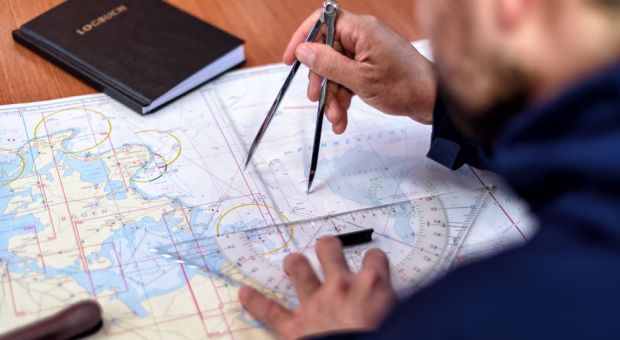
The first thing to do at this point is to try narrowing down your location by triangulation, if you can’t pinpoint it from hand rails. Triangulation consists of taking bearings on two obvious features that you can see and can locate on the map. These features might be things like radio towers and road intersections, but they could also be a bend in a river or the peak of a mountain. You use whatever you have.
To triangulate, you need a good compass; one with the degrees marked on it. Ideally, you’ll have a declination adjustable compass, which allows you to adjust for the magnetic declination between magnetic north and true north. The topographical map should tell you the magnetic declination for the area it covers, in the map’s information block.
Use your compass to determine the bearing, in degrees, from where you are to your two recognizable features. The more accurately you can do this, the better. Then, mark a pencil line, creating a reciprocal bearing (opposite direction) from each of those features back to you.
- If the bearing is less than 180 degrees, you find the reciprocal bearing by adding 180 to it.
- If the bearing is more than 180 degrees, you find the reciprocal bearing by subtracting 180 from it.
Where those two lines cross is where you are. How accurately that will locate you will depend on how clear your terrain features are, the scale of the map (a smaller scale will give you greater accuracy) and how well you did your work.
The next step is figuring out where you want to go and how to get there. The topographical map will help you there, as it will allow you to see what the terrain is like around you and between where you are and where you want to go. This will allow you to pick a route that meets your needs, whether they are to remain hidden from prying eyes or to get yourself back to camp the easiest way.
Using Dead Reckoning
Triangulation is great, when it works. But there will always be times when you can’t see usable landmarks. This could be because it is nighttime, because of inclement weather or just because there are no obvious landmarks within visible sight. Can you imagine trying to triangulate your position when you’re in the middle of the flat plains Kansas farmland?
You have three basic ways of figuring out where you are, what we could call your starting point:
- Tracking yourself as you travel
- Using hand rails to locate you
- Triangulation
There’s actually a fourth one, using a sextant to determine your position, but that’s normally only used when out in the middle of an ocean. I don’t carry a sextant in my survival kit and I don’t expect you will either. Although I will say that an antique brass sextant would look nice sitting on a shelf in my office.

The ability to see landmarks is not only important to figure out where you are, but also to determine where you are going and how far you are along the way. But what do you do, if you can’t see well enough to pick out those landmarks? That’s where dead reasoning comes in.
The basic idea of dead reckoning is that you travel in a known distance for a known direction from a known starting point. Assuming that all three of those things are at least fairly accurate, you should have a pretty good idea of where you are at any particular point in time along that way. By making periodic stops and marking your progress on the map, you can keep yourself from getting lost.
The easy part is in knowing what direction you are traveling. Any compass will tell you that, assuming you know how to use it. If you can see well enough to pick out landmarks ahead of you, you can walk towards those landmarks, keeping yourself on track. If you can’t see the landmarks, you’ll need to look at your compass frequently, so that you can maintain your bearing.
Maintaining your bearing can be challenging enough in rough terrain, but if you’re careful, you shouldn’t go far off. The harder part for most people is figuring out how far they’ve gone. In days gone by, pilots figured this out by their airspeed; traveling so long at such and such a speed equals so much distance. But we can’t count on that. We need to count our steps and convert that to distance.
The length of your stride will vary, depending on a variety of things, such as: how rough the terrain is, how tired you are, whether you are walking uphill or downhill, the weather, daytime verses nighttime, and your health. Nevertheless, you need to find out what your average stride is, for a variety of different scenarios.
I remember doing this in the army, where we would have to walk 100 meters in a variety of different conditions, over and over again, to determine what our personal stride was. We would count every left step, making a stride two steps (right-left). So, in other words, we were trying to find out how many steps we took in those 100 meters. Knowing that, allowed us to count our strides while doing dead-reckoning navigation and tell how far we had gone.
On a road march or map problem, two people were given the responsibility of counting their steps. These would not be the point man or the rear guard, but rather, someone in the middle of the group. Using two meant that if one lost their count, we would still have a count.
Every time we changed direction or took a break, the men who were counting would convert their count to distance and then take the average of that distance. That would be marked off on the map as the distance we had covered.
Obviously, dead reckoning isn’t perfect. Measuring how far you’ve gone by your stride is not an exact science, no matter how hard you might try to make it one. When traveling through rough country, staying on bearing can be extremely difficult. Even so, at the absolute worst, you’ll have an idea where you are, within a couple hundred yards, at all times.
When navigating in this manner, you want to take every chance you get to use a hand rail to update your position fix. You will probably find that you will be close, but that you’ll need to make adjustments. That’s okay; the main thing is, you won’t be lost and you’ll have a good idea of how to get where you’re going.
Final Thoughts
While map reading and land navigation skills aren’t all that complicated, doing them automatically takes some practice. You really don’t want to wait to learn them, until you need them. By then, it may be too late to learn.
The other important thing is to make sure that you get in the habit of using a paper map to back up your GPS, when you’re out in the country. That GPS could fail at any moment, leaving you wondering where you are. It really doesn’t take long to locate yourself on the map, if you have the coordinates from a GPS.
Besides, taking that moment will help you put the land around you in perspective, so that you can enjoy it even more.


Topos combined with a pocket altimeter can locate a person very easily. I’ve used both in crass country navigation.
Chuck
“crass country navigation” I love it.
I’ve never used a GPS. Don’t own one. Ive always used a map. Even if it’s from a computer. I always print it out and then highlight my route. I love me some maps.
I love maps too. Have been collecting USGS topos since I was a kid, and still do. I have most of the maps available for my state, and many others.
I find them fascinating to pore over, studying every detail, and have discovered many interesting places that I later investigated in person from doing that.
This is good advice here. One thing is for sure, when you are surrounded by woods, it is hard to see many landmarks, but you learn to recognize features like hills, valleys, streams, etc. and usually can get a clue about your location.
Never had a GPS, seems too easy, and not help if it fails. I like the idea of having an altimeter, to go along with the compass. That could be a big help.
GPS is a rwo-edged sword. While it can give you a good idea where you are, it also tells Big Brother where you are. Think about that, if you ever need to escape and evade….
A past friend was so dependent on GPS that he would get lost while trying to visit me before he got it. Going anywhere, it would usually direct him to take the longest route. When I went somewhere with him, I always asked him to turn off that bloody annoying thing and just turn when I told him to turn.
The day my friend moved to another state, he still had that GPS device telling him where to go…..
Hi Kevin, Nope, GPS does NOT tell Big Brother where you are – your GPS in the hand is purely and simply a receiver – it is NOT transmitting anything back to the satellites.
Bill Balharry
GPS is nice, but as far as I’m concerned, it’s always secondary or supplemental, not primary.
Just saw on One America News yesterday where Iran is messing with GPS to divert shipping into their waters for possible hijacking.
One America?? That’s full-on tinfoil hat conspiracy programming. I’d love to know how Iran can possibly alter gps equipment they don’t control.
You might try looking into the actual facts about conspiracy “theories” they’re nearly ALL found to be the truth.
Have always loved maps. Only have one friend who shares that love. I find it almost impossible to let go of an outdated map!
There is a lot more benefit to map-compss+waterproof-paper Log Book than just getting back to the trail head (where you may have started) or your car.. If you are really-really out in the boonies you may need to consider “your camp” as extending 100-yards in any/all directions around your tent or sleeping place. In bear country you certainly do not want to place your food right in your tent, or near it, when 100 yards away would be smarer; but in a forest you may not be able to find it without writing down the bearings and your ‘paces or stride (right/left=1)’ from your sleep place. Same thing with your ‘crapper’. Building Codes say position it downhill from your main dwelling, and the codes dictate how many feet from dwelling and/or any bodies of nearby water or well. Every Prepper has heard that you cannot bring everything you want and think you need; but if you knew where you wanted to be, you could pre-position cached items (and in more than one spot, with the idea being “don’t put all your eggs in one basket”). Writing down all needed info (bearing, paces, landmarks (and/or sign indicators you may have made to refind a location)–important as seasons change the appearance of many landscapes), and depth (if you buried something) or height (if you placed it in the crotch of a tree); and the contents of different caches is critically important to rapid recovery.
Other important things to note is that magnetic compasses have a 2-degree range of error that over long distances can put you 100s of yards off course (which is why you need to re-take bearings along the way). Don’t stand near a farmer wire fence and take your bearings. Be 50-feet minimum away from your car. Never take bearings in your car. If you are carrying a rifle over your shoulder and taking bearings, your bearings will be at least another 1-degree off the magnetic bearing with declination factored in (so now you are 3-degrees off map+compass bearing. So take bearings away from your metallic gear. Don’t take bearings near an old-time trash dump (e.g., farmer’s dump, where all that is left is metal debris in ground and broken glass and pots).
True story, two next-door neighbors decided to bury a can of modern coins in a field directly across the street from their homes, and a year later to go out and recover what they had buried. They had heard stories about lost loot (and lost mines) and wondered how that could happen. So they mapped the field (by dead-reckoning–eye-sight) and in relation to features in the field. They counted paces from their starting place and from landmarks and wrote them down. A year later they went to recover it, and COULD NOT FIND IT (and did not know why). They thought they had done everything correctly. Here is what happened, They did not write down the depth, relying only upon their memory. They had found the correct location, but didn’t dig deep enough because in their memory it was only “arm length deep”, but not “arm and shoulder length” deep (which it actually was). On the second attempt they dug another foot deeper (about 36″ total) and found it. Their first dig was about 28-30 inches deep (not deep enough). So again, take notes and write down every detail. THE DEVIL IS IN THE DETAILS (the ones you didn’t write down).
True story, I once went caving with a group of 8. We visited a honeycomb cave with tunnels going every-which-way, including above us. The entry on the outside was a hole (not more than 36″ wide) near a tree on a gentle slope. To get inside the chambers I had to move myself along ALWAYS with my belly touching the entry tunnel floor (no crawling on knees and hands). I had to slither, in prone position (flat on belly), but at one point I had to inch-worm, meaning push my belly to head one-inch forward, then pull my hips and legs one=inch to “catch up”. I was lean in those days–no belly fat. It was a tight squeeze that scared the crap out of me, but the narrowness was just in one place (and about 1 foot long in part of the entry tunnel). I kept following the voices ahead of me and breathed a sigh of relief when I entered the first chamber, where I looked around with a flashlight, though my eyes were not accustomed to the darkness yet, along with the flashes of other people’s flashlights bouncing off the walls, so I got little snapshots of the chamber, but not the big picture. . The chamber was about 4.5-feet high and at least 10=feet by 10-feet.. I saw what appeared to be other tunnel entrances (they were “shadow spots”), but I didn’t make a basic map of that chamber. I didn’t count the tunnels and their positions. I didn’t number the tunnel that gave me entrance to the chamber. And in the entry tunnel it never occurred to me to “count my crawls (so-to-speak)” and get a sense of distance. It took me at least 10 minutes, because I was moving slowly and carefully to enter the main chamber (though it may have been only 20-25-feet). All of these things that I did not do resulted in me getting lost (not knowing where I was, nor which way to go) in that cave and in the entry chamber. I was panicky. What scared me most was a guy in a “crawling on all fours” tunnel directly above me that had a hole in the ceiling above me (that I did not see because I was crawling “face down to where I was proceeding). As soon as I was directly underneath that hole, the guy grabbed my hair and yelled scary-loud. Within a minute I decided it was time to leave that cave. When I re-found the entry chamber I started noticing all the tunnels that entered it. I went to one (it was the correct one), but about 10-feet into it– it was nothing like I remembered so I backed out to go into another tunnel. It was filled with cob webs, so I backed out. A different tunnel dead-ended about four feet in. Finally I asked someone which way was out; and I was sent to the proper entry tunnel.
So here are the learning points: (1) how things appear walking in one direction can appear very dfferent in the opposit direction; and seasons change everything too. (2) Memory can be mistaken when you are panicky. WRITE DOWN IMPORTANT FACTS when you first enter a strange area. Make a map noting key features (including bearings). (3) If others accompany you, brief them before you start and have them write down all the important info: pace-strides, (even crawl-strides if need be), landmarks, etc. should they become separated. (4) Plan meeting spots should someone be separated. Buy waterproof Log Books on graph paper (and bring pencils), so you can write notes and draw maps. Carry them with you anywhere you could get lost.
There is plenty more info to share. For example, roads on maps are “out of scale” so you can see them on the map. That means the distance to a road will likely be 100-200 yards further than what you can see, because they are not drawn to scale. This is where “handles” and bearings are important…just keep walking until they show up. A second fact, because compasses can be 1-2 degrees “off”, many people shoot for a long hike at 3-degrees off to ensure they are “to the right” of their destination target, because that way they know after so many paces that they now proceed 90-degrees (to the left) until they reach their desired destination. Consider the alternative (my “cave story”). You reach what you thought was your destination, but you don’t see what you are looking for. Do you go to the right 100 yards, then back track 200 yards trying to find your target location? You could really waste a whole day walking around in circles, whereas if you intentionally aimed to be off by a degree or two, there would essentially be only one direction for you to be concerned with, even if you wasted half-a-day searching for it.. Bringing pair of binoculars to save steps. BTW my state has forests, swamp/grasslands, farmer fields and lots of creeks, lakes; and it snows plenty in winter.
In grade 11 I was 15 & Mr hale our geography teacher taught us to read topographic maps. The example he chose was a heavily emaciated area which included the university of guelph (ONTARIO, canada). Eight years later my parents moved to that area. Years passed and I obtained a 5th career, this one being as a federal law enforcement officer. Our main training site appeared on that map where I was 15, but now I was almost 50 y.o. map reading was a skill that I excelled at when few of my classmates cud figure it out. I’m regretting that my first wife had absconded with my pocket altimeter.